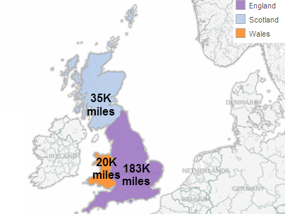
In England, Scotland and Wales, local government is responsible for all roads that fall outside the jurisdiction of the Strategic Road Network (explained in the introductory post on Motorways and Trunk Roads).
Local Road Classification
- Principal ‘A’ Roads – (green coloured signposts, green or red colouring in road maps and atlases)
- B Roads – (white coloured signposts, yellow/brown colouring in road maps and atlases)
- C Roads – (white coloured signposts, white colouring in road maps and atlases)
- Unclassified Roads – (white coloured signposts, white colouring in road maps and atlases)
This Wiki provides a little more background. Or, for real road enthusiasts, check out Chris Marshall’s British Road Directory. Although no longer kept up to date, this is a fantastic resource to learn about Britain’s roads.
These road classifications are primarily administrative. Whilst A and B roads are distinguishable to road users by the particular colour and style of road signs and map / atlas formats, the distinction between C and Unclassified roads is not obvious on road signs or in maps / atlases. Some C roads are signed though.
C roads appear to have a bit of a cult following, so if you want to know more, the Great C Road Hunt (by Chris Marshall) is the place to start.
The difference between Major and Minor roads
- Principal ‘A’ roads are referred to as Major roads.
- B, C and Unclassified roads are referred to collectively as Minor roads.
- This is not the same as the use of the terms Major and Minor when learning to drive, as this discussion thread by driving instructors highlights.
Local Highway Authorities
Local authorities in each country (England, Scotland and Wales) are responsible for the design, maintenance and management of all local roads in their area:
- In England, 153 local authorities (of both single tier and two tier structures – see English Regions Map for details ) manage their own local road network. From 2015, Local Transport Bodies will co-ordinate major local road schemes regionally,
- In Scotland, 32 Unitary (single tier) authorities work together in seven Regional Transport Partnerships to manage local roads with a regional strategic focus
- In Wales, 22 Unitary (single tier) authorities manage roads locally, but work together in four Regional Transport Consortiums to give a regional transport focus.
Road Length Data
With data from the road lengths dataset for Great Britain (2012), we can get an overview of the key facts and figures for local roads in Great Britain.
By combining this data with cost, road condition and other datasets, we’ll be able to build a more detailed picture of how well local roads are being managed, and where there are opportunities to share learning across Great Britain to deliver better value for money services.
